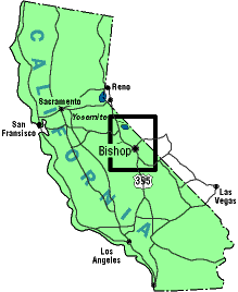
The Town:
The town of Bishop is your closest and best bet for vittles and
anything else you might need for bouldering. Bishop is a full
service town that has tons of motels and numerous campgrounds
nearby. Be forewarned that during the big hoe-downs (Labor Day,
Mule Days etc) rooms are scarce, so plan on camping. Camping at
Horton Creek Campground is the preferred method and has a lot
to offer. Don't blow it by taking dumps in the river or raging
all night on chemicals and running around naked. Just chill and
all will be well. Most stores in town do not carry Olde
English 800. Lucky for us the Mobil Mart gas station stocks a
few 40's of this elixer. Might be the only place in town doing
so, so stock up when you gas up.
Eats and stuff:
Eats are no problem in Bishop, whether you are a vegetarian or
carnivore, you can find it here. A few suggestions: Sizzler
has meat and a salad bar. Freshness is always suspect. Taco
Bell...for $8.00 you can kill two people. Jacks Waffle
Shop, although not open 24 hrs anymore, it is still a good
bet for American breakfast fare right down to the American Cheese.
Bubbas Grill is also a morning favorite. Whisky Creek
for all meals is a good bet. Not as expensive as it looks and
the best microbrews in town. Stay away from the Fish and Chips
as this little entre is famous for giving even the heartiest masticator
a full-on dose of butt-water. For pretty good Chinese, try the
Imperial Gourmet, behind Baskin-Robbins. A new Thai place
called of all things the Western Kitchen serves up a great
array of fine food. They are located on Main Street, just past
K-Mart. Mex food you ask? Try la Casita on Main St., just
south of W. Line Street. Bring cash, 'cause they don't do credit
cards. Another fine Mex place is the las Palmas Taqueria,
on east Line Street, across the street from la Casita by the old
Vons Market on the south end of town. Pizza? Nick and Willies
is the best, but for the parlor feel, try the Pizza Factory
just past K-Mart on Main Street.
Local entertainment can be found at the Kava Cafe next to the famous Wilsons Eastside Sports, right in the center of town. Good food, great coffee and guys with beards playing music on some nights. It's neo-retro-grassy-ambience at its' finest. Be sure to stop into Wilsons for chalk, local beta, a quick resole, or just some star gazing. I heard that Fred Nicloe was in there buying a roll of tape.....Rustys Saloon features Friday Night Live Music. Not bad either, and only a few doors down from Wilsons.
Weather:
The summer bakes out at the boulders in Bishop and most of the
bouldering is done right after the sun goes over the mountains.
In the spring and fall, the weather is perfect, but snow is possible
at times during the winter and a bone numbing wind can creep up
at anytime. The winter can be harsh and chains will be required
after any big dumps above 4000ft. Finding a warm problem or two
is usually pretty easy all winter out on the Volcanic Tableland,
just avoid the odd snow patches.
Access Issues: Short Version:
As with all areas, access could become a problem. The BLM is watching
the situation at many of the boulders and flexing their government
muscle to push their idea of what should and should not be going
out on the Tableland. Main point: The land is public and for our
recreational use. Remember this, but don't be an anus about it.
The BLM thus far has been pretty cool yet still looks upon us
as potentially more paperwork and bigger headaches. This may or
may not change the way things are done, but for now watch your
trash, no off road driving, no injuries, no blatant homesteading
in you van, no fires, no atomic weapons. Be wary of cattle on
the roads and at the boulders. Use turnouts or obvious parking
areas. Respect any pictographs or artifacts you may happen upon.
Breif nudity is acceptable in remote areas, but not on any highway
or mining claim. For tons more info on access and how we can
protect our recreational use of the land, see our BIG ACCESS PAGE, sponsored by Wilsons Eastside
Sports and RockFax Guidebooks.
The Actual Boulders:
Getting to some of these areas will be a problem. I will attempt
to describe the approach etc. but you may still never find them.
Ask around to get better beta or to be taken to the more remote
areas. Who you gonna' ask? Start in Wilsons and go from there.
As available, topo guides are listed for each area. You might
have to do some leg work to collect them all, but have no fear
for RockFax is working hard and fast to produce a guidebook to
the entire East Side Bouldering circus. This will be out in late
2001 and will feature all the best and brightest in the entire
area. For those of you who put up new problems or have any corrections
to add to already available info, please send it in. Don't just
sit there and cry about how your boulder problem was re-named
and downgraded by those selfish active locals...send in the info.
We ain't Marvin the Mindreader, and if you don't let us know,
your grand achievement will be swept into oblivion.
Just ask those that are weeping now. Email any info to Mick at RockFax Guidebooks.
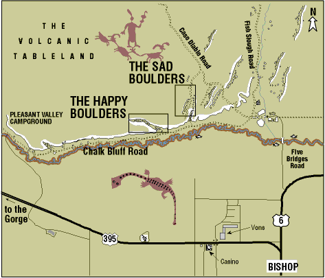
Volcanic Tableland Boulders:
Happy Boulders:
If you are camped at Pleasant Valley campground just motor
down the Chalk Bluff Road for 3.7 miles and park next to the Singing-Ringing
tree. Take the marked trail opposite into the canyon. From Bishop,
take Route 6 for a mile to a left on Five Bridges Road. Follow
this just past the gravel works to the three-lane junction. Motor
down Chalk Bluff Road for 2.3 miles to the Singing-Ringing tree.
Use the sign-n box and park straight in. Be on your best behavior
while here at the Happy Boulders. This area is under the BLM microscope
and is a test case for future access. Stay on the established
trails as to be sure and trip the use counters buried in the ground
under the main trail (no kidding!) Hello BIG BROTHER!
Topo Info: Rock and Ice Magazine did a topo guide in issue
#83. Climbing Magazine did a topo guide in issue #182. RockFax
Guidebooks has done the best guide to the Happies and is available
at Wilsons or direct from RockFax Guidebooks.
Sad Boulders:
From Bishop: Take Route 6 for a mile to a left on Five Bridges
Road. Follow this just past the gravel works to the three-lane
junction. Set your odometer to zero. Take Casa Diablo Road, the
middle of the three roads, up the hill, past some bluffs, past
a left turn and at two miles take a left. Follow for 300 yards
to a left turn at the bottom of a small hill. Follow this bumpy
road, heading south for one mile to the parking area, next to
some slabs. The canyon is down a short trail on your left (east).
Topo Info: RockFax Guidebooks has an online topo available
to the Sads. See it at the RockFax site by clicking HERE.
 Lonely Boulders:
Sorry, ask around and be taken there.
Topo Info: No topo available (yet).
Sexual Hangup Boulders:
Sorry, ask around and be taken there.
Topo Info: No topo available (yet).
Despondent Boulders:
Sorry, but it is rumored that the BLM will have a conniption
if these boulders are "outed". Let's just say they are
past the Lonelys, past the Sexual Hang-ups, and before the Powerline
Road. Go ahead and trample at will trying to find them. From an
impact standpoint I just don't see it..... If you find it, be
wary of any artifacts from an indigenous culture. Leave these
items alone and be kind to the past.
Topo Info: No topo available (yet).
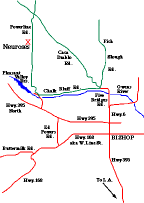
Neuroses Boulders:
Follow Casa Diablo Road until it intersects another main road
with power lines and towers running along it, 9.9 miles from the
junction. This is Powerline Road. Go left and then drive 2.1 miles
until a small road appears on the right in a wash. Parking is
near the base of one of the towers. From Pleasant Valley Campground,
head up the steep dirt road for 6.0 miles. The road and wash described
above will be on your left. You will see a small bluff off to
the West about .5 miles from the road. These are the Neuroses
boulders. The two largest boulders as you approach are the Jung
and Freud boulders.
Topo Info: Click Here
for a PDF topo of the Neuroses area.
For a PDF version of this map to print, click HERE. It also includes mileage for the Sads
and Neuroses.
Granite Boulders:
Bards Camp:
Just before you get to the Peabody boulders (see below), there
is a dirt road leading left away from the main Buttermilk road.
Follow this road untill you cross the creek and enter a small
valley. The boulders are up on a hill to your right.
Topo Info: No topo available (yet).
Buttermilk Boulders:
Take Hwy. 168 (aka W. Line Street) west out of town for about
8 miles. Take a right on Buttermilk Road. Go another 3.5 miles
until you see the grand Peabody Boulders on the right side of
the road. If you can't find these boulders, look into a new sport.
Topo Info: Numerous attempts at topos have been done. Some
bad, some good. The RockFax output is far and away the best available.
You can try the Vogel Guide (bad), the Monier Guide (really bad),
an online guide at Bouldering.com, (pretty good) or just buy
the new guide from RockFax included in the Bishop Bouldering
Survival kit available at Wilsons Eastside Sports in town. You
can also see Kevin Thaws guide to the Buttermilk, which is on
the Power and Rubber site, by clicking HERE.
Bardini Boulders:
Continue up the Buttermilk Road, past the Peabodys, to the
cattle grate. From the cattle grate drive about 2 miles up the
main road. There is a road that takes off on your right. Park
here or go about 1/4 mile further up the road to one of the turnouts.
Walk down hill to the river and then cross with caution on the
right edge of a cliff band before working your way uphill in a
sandy gulley. Continue up and slightly right for about 15 minutes.
After popping over a slight hill you will see a flat area with
a cluster of boulders. Start bouldering. To see what the approach
looks like form the parking spot, click HERE.
Topo Info: No RockFax topo available (yet). There is an
online topo available to the Bardinis from Bouldering.com. Go
see it at Bouldering.com.
Sherman Acres:
Once the secret domain of John Sherman (who hasn't been here
for a decade) is now available to any and all punters....not that
they will go up there anyway. Follow the same road past the Buttermilk
Boulders for about 2.75 miles until a road appears on the left.
Take this road a few hundred feet to the parking area. From here
start hoofing it to the right of Grouse Mt., the big blob in front
of you. The boulders are on the west flank of Grouse Mountain.
The other method involves continuing up the main road until it
crosses McGee Creek, a seasonal ball-ache. Keep following the
road as it moves right and away from the boulders for another
bunch of miles. Eventually it will start back left and head toward
the boulders. A long and grim drive at best. A 4-wheel drive is
close to mandatory.
Topo Info: No topo available (yet).
Druid Stones:
Directions to the parking area: From Wilsons Eastside Sports
head south and take a right at the lights onto West Line Street
as if going to the Buttermilk. Drive past the Post Office, through
the first set of lights,past the Hospital, to the second set of
lights. Make a left here onto Barlow Lane. Follow Barlow through
a residential area, past Schrober Lane to open farmland. Take
the next rightonto a paved road into the desert. This is Chipmunk
Canyon Road. Go to the second powerline and take a left onto a
dirt road. Take the first right and continue just past a corrall
to theend of the road before the big gully. Park here.
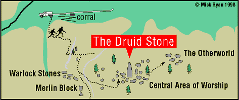
Directions from the parking area to the Druid Stone:
Follow a trail on that contours the left-side of the gully then
switchbacks up the hillside to three white pipes. Continue east
and up the trail turn sright before a broad wash. The trail follows
the right side of a broad wash. Go straight up until on your left
is a 20ft high pinnacle with some cairns on top. Follow the trail
past this landmark, up and left past two trees. The trail levels
off after the trees. The trail forks, take the right fork, eventually
passing a nice steep slab - the Resting Boulder. A little further
you will see the DruidStone, a 70ft high pinnacle on your left.
The trail heads up by the side of a wash going towards a very
square looking boulder - the Merlin Block. A trail branches off
left going downinto a wash then up through boulders heading towards
the Druid Stone. About 40 minutes hike depending on your aerobic
capacity and the tightness of your trousers.
Topo Info: See the Bishop Bouldering Survival guide by
RockFax Guidebooks.
Granite Ranch: Sorry! Still Secret.
Topo Info: No topo available (yet).
Megawatt Boulders: Sorry! Still secret.
Topo Info: No topo available (yet).
Rimmer Ridge: Sorry! Still Secret.
Topo Info: No topo available (yet).